
Welcome to the website of our collaborative UK – Indonesia research project:
“Enhancing the benefits of tropical peatland restoration for supporting local communities and ecosystem processes.”
Why study tropical peatlands?
Tropical peatland systems in Southeast Asia have been modified and degraded in various ways: logging, drainage, conversion to agricultural land uses, and burning. These processes have led to carbon emissions, damaging haze, and negative impacts on forest ecosystems and biodiversity.
In Indonesia, commitments have been made to restore peatland in order to tackle the negative impacts of degradation. Restoration includes rewetting drained areas and changing the management of peat land covers. We are interested in the outcomes of this restoration for people and the environment.
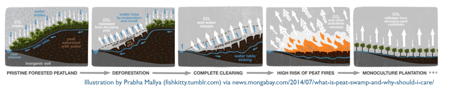
What are tropical peatlands?
Peat forms by the partial decomposition of vegetation under very wet conditions. In temperate environments, peat tends to be formed from mosses and non-woody vegetation, but in the tropics, peat is generated from woody material (trees and shrubs) due to the warmer and wetter conditions. This means that peatlands originally formed under various types of forests. Peat soils are very acidic, meaning vegetation that grows on them is highly specialised, and they store large amounts of carbon.
Peat swamp forests in Southeast Asia contain unique biodiversity, and are important refugia for forest biodiversity following widespread deforestation of other tropical forest types in Southeast Asia. Only ~29% of peatland in Southeast Asia is thought to still be covered with forest – the rest has been converted to agriculture/plantations, or is degraded (non-forest, non-agricultural land).
What research is happening as part of this project?
Our project focuses on tropical peatlands in Sumatra, Indonesia, with field, remote sensing and modelling research in Jambi province. We have several research themes, which different members of the team are focussing on:
- Mapping peatlands and their degradation (ZSL)
- Assessing biodiversity in peat forest and peatland agricultural areas (York, Jambi)
- Investigating the connectivity of peat forest areas (York, Liverpool)
- Understanding the needs of local communities and the socio-economic impacts of peat restoration (Leeds, Jambi)
- Understanding greenhouse gas fluxes, water tables and soil microbial diversity (ICALRRD/BB SDLP)
- Identifying priority areas for peat restoration projects (All)

Who is doing this research?
We are a multi-discplinary team from institutions in Indonesia and the UK: click here to find out more about the team.
![]()
We are supported by the following funders:

